 |
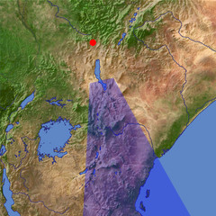
| Kenya Section of the Rift Valley |
Great Rift Valley is a large breach of the crust of the earth where the African continent showly splits into two parts. Many lakes can be seen along the rift one of them being Lake Victoria, the largest Lake in Africa. Volcanic valley formed 10–20 million years ago owing to rifting (major subsidence through faulting) of part of the Earth's crust, it a geological fault system of SW Asia and E Africa. It extends c.3,000 mi (4,830 km) from N Syria to central Mozambique. The northernmost extension runs S through Syria and Lebanon, the Jordan valley, the Dead Sea, and the Gulf of Aqaba. It continues into the trough of the Red Sea and at the southern end branches into the Gulf of Aden, where it continues as part of the Mid-Oceanic Ridge of the Indian Ocean. The main section of the valley in Africa continues from the Red Sea SW across Ethiopia and S across Kenya, Tanzania, and Malawi to the lower Zambezi River valley in Mozambique. Many small lakes in Ethiopia and several long narrow lakes, notably lakes Turkana and Nyasa, lie on its course. Just N of Lake Nyasa there is a western branch, which runs north, chiefly along the eastern border of Congo (Kinshasa); this branch is marked by a chain of lakes, including lakes Tanganyika, Kivu, Edward, and Albert (Mobutu). Lake Victoria does not lie in the Great Rift Valley but between its main and western branches. The Great Rift Valley ranges in elevation from c.1,300 ft (395 m) below sea level (the Dead Sea) to c.6,000 ft (1,830 m) above sea level in S Kenya. Erosion has concealed some sections, but in places, notably in Kenya, there are sheer cliffs several thousand feet high. The present configuration of the rift, which dates from the mid-Pleistocene epoch, is probably a result of a rifting process associated with thermal currents in the earth's mantle there is evidence of earlier rift structures.
No comments:
Post a Comment